On September 23, 2025, the city of Kristiansand and a network of emergency partners gathered their top emergency personnel for a full-day disaster simulation. The scenario: extreme rainfall, rising rivers, potential quick-clay landslides, road closures, power loss, and community-wide evacuations.
It wasn’t a theoretical exercise. Led by Sigurd Paulsen, the chief of emergency, the simulation used real data from a real disaster – the October 2017 flood that brought Kristiansand to a halt. Over three days that year, unrelenting rain overwhelmed local infrastructure: tunnels filled with water, homes and businesses were inundated, bridges collapsed, and train lines were washed out. Entire areas went dark without electricity. The damage was immense, though thankfully, no lives were lost.
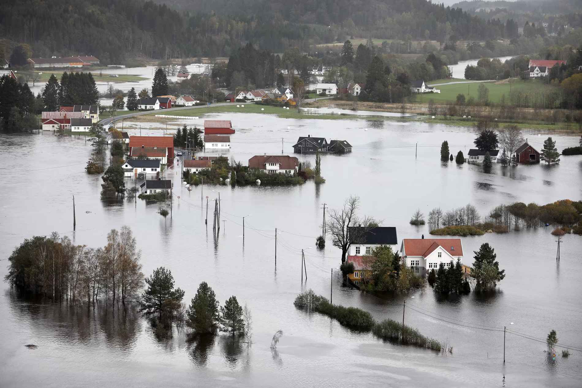
IMAGE: Fædrelandsvennen
In 2025, the question was simple: What if it happened again tomorrow?
To answer that, the municipal crisis team simulated the same scenario, hour by hour. This time with better tools, more coordination, and Intoto’s real-time water level data platform powering the room.
A Crisis Room Comes Alive
By 08:00 on the morning of the simulation, the crisis coordination room at Kristiansand City Hall was already buzzing.
About 25 key personnel gathered from municipal divisions under the leadership of Sigurd Paulsen, Kristiansand’s chief of emergency. Connected online was a network of representatives from the police, fire and rescue, Glitre Energig and Norwegian Water Resources and Energy Directorate (NVE).Local media followed parts of the simulation, including NRK Sørlandet. Everyone had the same goal: to practice, with realism, how the community would respond if severe rain once again pushed the region to the brink.
The Tools That Held the Room Together
Three digital platforms became the backbone of the simulation:
- RAYVN – the national standard for disseminating emergency information to the public
- Intoto/Verden – for live water levels and infrastructure visibility
- NVE Temakart – for hazard maps (flood risk, quick-clay zones)
- Municipality internal mapping tools – i.e. number of people living in certain areas
Weather forecasts were taken via phone calls to MET (Meteorologisk institutt) as needed.From the start, Intoto’s platform, branded as “Verden in the room,” was one of the most-watched displays. Teams repeatedly turned to it to track water level changes, assess flood zones, and decide on real-time responses.
How the Scenario Unfolded
The simulation followed a fast-paced, hour-by-hour sequence modeled on the real 2017 event. Each new development required immediate response.
- 08:00 – Briefings began. Glitre Energi warned of risks to municipal buildings and to Kjevik Airport’s power systems. Rain had already driven rivers like Tovdalselva beyond alert thresholds.
- 08:50 – The first infrastructure hit: a municipal road at Drangsholt went underwater. A nearby riksvei, or local road, was also expected to close.
- 09:25 – Reports came in of soil instability and cracks at Kvalermoen, an area nearby a river, prompting a rapid decision: evacuate 150 residents to Tveit idrettshall, and eventually to the emergency shelter at the Ve school.
- Mid-morning – Information overload set in. There was nonstop discussion but no structured status updates. Teams stumbled over local place names (e.g., “Stokkeland bru” vs “Langenesveien”)—a small but critical delay in decision-making.
- Late morning – A flurry of new issues arose: a bus accident, a water main break, and threats to the power grid. NVE and MET provided updated river forecasts—flood peaks in Tovdalselva were now expected ~12 hours after the heaviest rain.
- Midday – Landslide risk entered the discussion. NVE updated the hazard maps, and teams debated public messaging, including multilingual SMS alerts. Auto-translate on the city’s website helped.
- 13:30 – A mock press conference was held by actual municipal communications staff.
- 14:30 – The health services team debriefed and flagged one key challenge: the lack of planned stop-points during the simulation caused overload and fatigue.
The simulation ended officially in the afternoon, but the Intoto-powered flood simulator kept running, because disasters don’t stop for meetings.
“Message from Intoto… now red.”
From the moment the simulation began, Intoto was one of the three core tools in constant use. Every time a river crossed a threshold—whether at Sagetjønn, Drangsholt, or Flaksvann—someone would speak up:
“Message from Intoto… now red.”
Heads turned. All eyes went to the big screen.
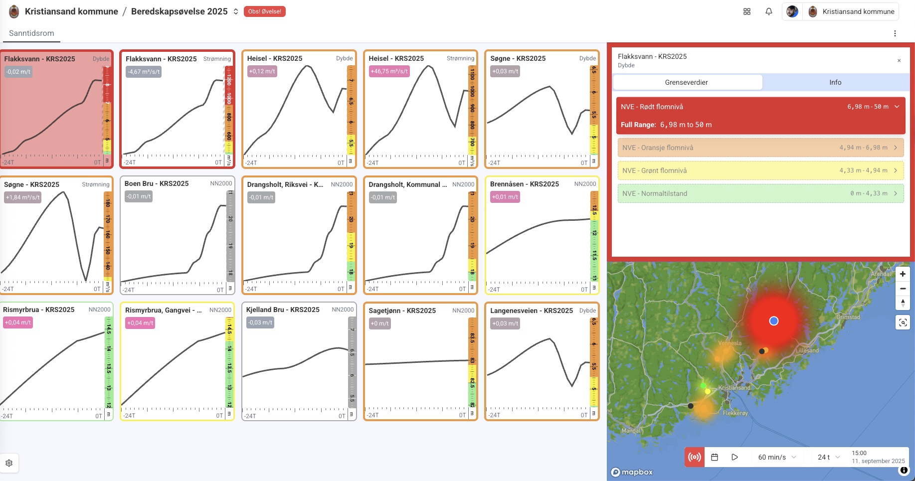
Intoto’s live map showed the evolving water situation across the region in real-time. Users could track river levels, forecasted peaks, flood zones, and infrastructure at risk. When Drangsholt’s local road started to flood, the team used the Intoto layer to see what would be hit next—roads, water mains, emergency shelters.
- Every alert came with a color code and a clear “why” line:
- “Red — Flakksvann above 1.2m (critical)”
- “Orange — Drangsholt Road nearing submersion”
- Teams could instantly see what was happening, where, and why it mattered.
- On the main projector, the display was clean and crisp, with a locked zoom level for group viewing.
One particularly powerful moment came when someone said, “Close Stokkeland bru.” (bridge) There was no confusion. The map displayed both local and official road names side by side, removing the ambiguity that had previously delayed action.
By the end of the exercise, our platform had gone from “just another map” to the shared picture of the crisis. It shaped evacuations. It drove coordination. It built trust.
What We Learned Together
Simulations aren’t just for practice. They’re for learning. And everyone in the room walked away with sharper instincts and a clearer plan for the next real flood.
Here are some of the key takeaways for Kristiansand’s emergency leadership:
1. Plan Stop-Points
Nonstop meetings led to overload. Instead, schedule clear, short status breaks every hour to understand change of situation, review, and re-focus.
2. Preload Place Names & Aliases
Local terms like “Stokkeland bru” confused some team members. Future simulations (and real events) should preload aliases and local nicknames into the platform.
3. Multilingual
Communication to multilingual residents is hard in crisis. Leveraging modern tools can help with live translations to ensure everybody can get and understand information.
4. Trust the Data—and Train on It
Because teams had used the Intoto platform before, they trusted it during the simulation. This reduced hesitation and built faster decision-making. But training is essential.
Why Simulate? And Why Intoto?
Kristiansand’s 2025 simulation wasn’t an abstract drill. It was a reenactment of a disaster that had already happened, and could happen again. By using real flood data, actual locations, and real-time updates, the municipality practiced how to act quickly and smartly under pressure. And at the heart of the response was Intoto.
Sigurd Paulsen, head of emergency services, Kristiansand said, “I believe that running an emergency preparedness simulation is an important exercise for any municipality. With the help of Intoto’s data, Kristiansand’s team could react as if we were in an actual, real-time emergency event. It showed us what worked and what we could improve. Most importantly, we believe the simulation can help save lives, homes and businesses.”
Municipalities across Norway already rely on Intoto’s Verden platform to track rising rivers, identify infrastructure at risk, and coordinate effective action. We provide live water level alerts, infrastructure mapping, custom flood zone overlays, and the tools to make them all understandable in real time.
Whether you’re managing a small landslide threat or a major urban flood, Intoto helps turn data into timely decisions.
Your Community Could Be Next
Kristiansand didn’t wait for the next disaster to get ready. Neither should you.
If you’re part of a municipal team, civil protection office, or regional emergency network, now is the time to simulate your own high-stakes scenario. We’ll bring the flood data, the visualization platform, and the expertise to make it real.
Run a simulation with Intoto. Learn fast. Act faster.
Want to talk with our team about setting up a simulation in your municipality?
📩 Contact us here
Explore the Intoto platform here
Or reach out directly at hi@intoto.io